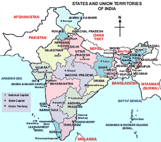
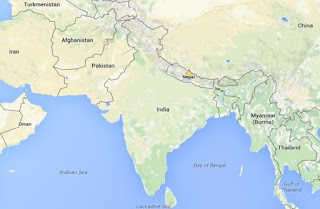
India is located entirely in the northern hemisphere, specifically in the south-central part of the continent of Asia. Indian Standard Time is ahead of Greenwich Mean Time by 5 hours and 30 minutes.
 |
| Know About Indian Geography |
India's borders run a total length of 15,106.70 km. Its borders with Pakistan and Bangladesh were delineated according to the Radcliffe Line, which was created in 1947 during Partition of India. With an area of 3.28 million square km, India is the 7th largest country of the world. The coastline of India stretches along the Bay of Bengal in the east and the Arabian Sea in the west.
Know about Indian Geography
1. Name the Assam's only hill station from where one can see the rainbow below?
Haflong
2. By which name is the line of control between India and Pakistan known?
Redcliff Line
3. Which are the oldest mountains of India?
Aravallis
4. In which state is the famous forest area named Silent Valley situated?
Kerala
5. Which oil field of India is the leading producer of mineral oil?
Mumbai High 64.55%
6. How long is Himalayan range stretched from West to East?
About 2500 kms.
7. Which was the first multipurpose river valley project set up after independence?
Damodar Valley Project
8. In which state of India there is no railway line?
Sikkim
9. Which is the world's second highest mountain peak?
K-2 Godwin Austen
10. Where does Ganga river ends its journey?
Into the Bay of Bengal
 |
| Know About Indian Geography |
11. Where do people called Tharu live?
Uttar Pradesh
12. Out of the tributaries of Indus river, which one is flowing through India only?
Beas
13. Where exactly is St. George island?
Near Vasco De Gama
14. Name the coast on which Cochin is situated?
Malabar Coast
15. What is the average height of Shivalik range of mountains?
1000 meters
16. Which state in India has the largest reserve of lignite coal?
Tamilnadu
17. Name the river which is known by six different names at different places?
Brahmaputra
18. The Malwa Plateau is flanked with which hills?
Aravali hills in North West and Vindhya in South
19. For which item is Makrana famous?
Marble
20. Which river is dividing the Aravali mountain range in two parts?
Banas River
21. Which chain of mountain lie in the East of Goa?
Sahyadri
22. Name the place in Uttaranchal (Uttarakhand) which Mahatma Gandhi called Switzerland of India?
Kausani
23. Which is the largest state in North-Eastern region and also the remotest?
Arunachal Pradesh
24. What is the height of Kanchanjunga peak?
8597 meters
25. In which country, India shares largest International border?
Bangladesh
26. Which is the smallest river amongst Jhelum, Chinab, Beas, Ravi and Satluj?
Beas
27. A Forest area in Kerala is known as Sairandhri Vanam, What is its famous name?
Silent Valley
28. What is the position of Indian Ocean in vastness amongst all the oceans of the world?
Third
29. Which state in the North-Eastern region has the largest and the most important varieties of wild life?
Assam
30. Which state is considered to be the Eastern gateway of India?
Assam
31. What is the common name given to summer crops of India?
Kharif Crops
32. Where is the oldest 18 hole golf course in India, Which attracts golfers from all over the world?
Shillong
33. The fortress of Agnipahar is attributed to Banasur and throws a light on the architecture and the skill of masons in those ancient days. In which place of Assam is this?
Tejpur
34. Which state produces more than 80% of the total production of Asbestos in the country?
Rajasthan
35. At which place India stands amongst the tobacco producing countries of the world?
Third Place
36. Where is the sanctuary for musk deer situated?
Kedarnath
37. Name the place situated on the confluence of three seas?
Kanya Kumari
38. When a stream of Ganga enters into West Bengal, What is its name?
Hoogli
39. What is the former common name of the North Eastern States of India?
NEFA
40. Which touring spot is called Shimla of Rajasthan?
Mt. Abu
41. Which union territory is between Gujarat and Maharashtra?
Dadra-Nagar Haveli
42. In which state of India only 17 persons per square kilometer live?
Arunachal Pradesh
43. Which important rivers of Deccan Plateau flow from East to West and merge in Arabian Sea?
Narmada and Tapti
44. In which state is the first port of India in private sector situated?
Gujarat
45. What is the distance between the two extreme points of India from East to West?
2933 Kms.
46. What is the distance between the two extreme points of India from North to South?
3214 kms.
47. In which sea are Andman-Nicobar Islands situated?
Bay of Bengal
48. Which separates Daman from Diu?
Gulf of Khambat
49. Which Indian state has minimum male literates?
Bihar
50. Which mineral used as nuclear fuel is found maximum in India?
Thorium
51. The shaheed Minar at Bir Tikendrajeet park is built in memory of the martys who fought the British in 1891, In which state is it?
Manipur
52. When a stream of Ganga enters into Bangladesh, by what name it is known?
Padma
53. Which place in India has lowest rainfall?
Leh
54. From which state does river Tapti or Tapi originate?
Madhya Pradesh
55. Which is the Indian state to have lowest forest area?
Haryana
56. What is the average height of Himachal range of mountains?
4100 meters
57. Which city is called the gateway of Nagaland which is a commercial centre and also has the only airport in Nagaland?
Dimapur
58. Which is the most cultivated crop in India?
Rice
59. Name the area in Jammu & Kashmir having less than 20 cm of rainfall in a year?
Leh
60. Which Indian state has lowest urban population?
Sikkim
61. What is the average height of the peaks in Himadri or great Himalayas?
6000 meters
62. Which river is reckoned to be the world's most majestic river in the North-Eastern region?
Brahmaputra
63. In which city is the head office of Geological Survey of India situated?
Kolkata
64. By which name is called the seven storeys palace with three storeys under water, built by Ahom King Rudra Singh?
Karenghar
65. In which state of India there is no railway line?
Sikkim
66. Which is the smallest state in the North-Eastern region?
Tripura
67. In which district of Arunachal Pradesh came the great 1950 earthquake equal to the force of 10,000 bombs?
Lohit
68. In which sea is Lakshadweep Islands situated?
Arabian Sea
69. Which is the highest sandal wood producing state in India?
Karnatak
70. Near which city is Bhim Betka having a collection of cave painting and discovered in 1957, situated?
Raisen (M.P.)
71. Which is the nearest railway station to Dadra and Nagar Haveli?
Vapi
72. Which is the largest flower producing state of India?
Karnataka
73. Where in India are situated Diamond Mines?
Panna (M.P.)
74. For which mineral is Kolhapur famous?
Bauxite
75. In which mountain range does Siachin glacier lie?
Karakoram
76. In which city river Ganges flows from South to North?
Varanasi
77. Which is the world's wettest place in Meghalaya state with the highest amount of rainfall?
Mawsynram
78. Where was the first cotton cloth mill of India established?
Kolkata
79. Which is the highest mountain peak in Rajasthan?
Guru Shikhar
80. Name the dam on river Son?
Bansagar Dam
81. Which place is called the gateway of western Khasi hills?
Moirang
82. In which state if India the sun rises first?
Arunachal Pradesh
83. Name the coast on which Chennai port is situated?
Coromandal coast
84. Which port of India is nearest to Indonesia?
Great Nicobar Island of Andman & Nikobar
85. The deposits of which mineral in India are maximum in the world?
Mica
86. Near which city is Bhim Betka, having a collection of cave painting and discovered in 1957, situated?
Raisen (M.P.)
87. Name the state of India where Asia's largest aluminium extraction plant has been set up?
Orrisa
88. In which state of India are highest numbers of Jute Mills situated?
West Bengal
89. At which place do Bhagirathi and Alaknanda rivers meet each other?
Devprayag
90. Name the river valley which is known for the largest deposits of coal.
Damodar Valley
91. In which state, one of the world's highest water fall situated?
Jharkhand, Near Ranchi
92. From which state river Ravi originates?
Himachal Pradesh
93. To which mountain chain K-2 (Godwin Austen) belongs?
Karakoram Chain
94. Name the two end points (cities) of National high ways No. 1
Amritsar and Delhi
95. Where was India's first paper mill established?
Serampur, West Bengal
96. Name one tributary of the Ganges which flows into it from the Peninsula Plateau?
Sone
97. In which district of Gujarat was the first dairy cooperative society set up?
Kaira (Kheda) District
98. Which major river forms part of North-Wstern boundary between Gujarat and Maharashtra?
Narmada
99. On which date was the first Indian meteorological satellite launched?
Kalpana-1, 12 Sept. 2002
100. Which mountain range contains the siachin glacier?
Karakoram Range
101. Which Indian port is not a natural port?
Chennai
 |
| Know About Indian Geography |
India is a land of great variety and its unique and ancient civilization has been a great unifying factor. The vast number of diverse faiths, beliefs, religions, lifestyles, languages etc. may confound a stranger, but in essence they represent the different aspects of one nation as do the petals of a lotus flower in bloom.
However social and economic inequalities, communal clashes can put a challenge to prevailing national harmony in India. Thus, unity among religions, communities, etc. is an absolute necessity. Any clash between communities can hinder the national harmony.
However social and economic inequalities, communal clashes can put a challenge to prevailing national harmony in India. Thus, unity among religions, communities, etc. is an absolute necessity. Any clash between communities can hinder the national harmony.

thank u blogger
ReplyDeleteThanks for your appreciation.
Delete